
Idaho Operations / Treasure Valley
Free Drone Scans
for Idaho Farmers
Noble Front Foundation deploys disabled veteran and first responder drone pilots to deliver 100% free multispectral and thermal crop scans to family farms across Canyon County, Owyhee County, Ada County, and the Treasure Valley.
Join the 2027 priority deployment waitlist.
Technology Demonstration
What We See That You Can't
Irrigation Failures & Crop Stress, Identified Early
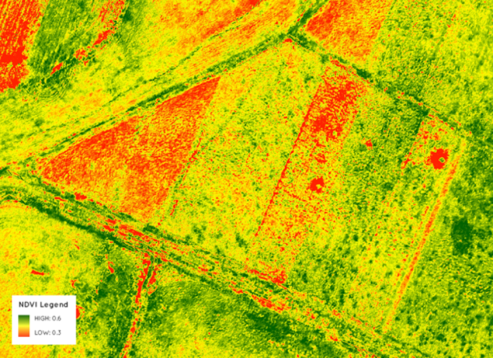
Our disabled veteran and first responder pilots fly multispectral and thermal sensors over your fields, capturing data invisible to the human eye. The resulting NDVI maps and thermal overlays reveal exactly where your crops are struggling and why.
In the Treasure Valley, where water is precious and margins are tight, catching an irrigation failure or early disease outbreak weeks before visible symptoms appear can mean the difference between a profitable harvest and a devastating loss.
- Detect crop stress 3–4 weeks before visible signs
- Pinpoint irrigation failures to the row level
- Map pest and disease pressure across every acre
- Generate actionable reports your agronomist can use
Operational Capabilities
What Our Pilots Deliver
Every scan is conducted by a Noble Front-trained disabled veteran or first responder, certified under FAA Part 107 and trained in precision agricultural imaging.
Irrigation Failure Detection
Multispectral imaging reveals hidden water loss, clogged emitters, and uneven distribution across your fields weeks before visible wilting appears. Our disabled veteran and first responder pilots identify the exact zones losing water so you can act before the damage compounds.
Thermal Crop Stress Mapping
Thermal sensors detect temperature differentials across your canopy that indicate drought stress, root disease, and nutrient deficiency. Canyon County and Owyhee County farms face extreme summer heat. We give you the data to respond with precision.
NDVI Vegetation Analysis
Our NDVI scans produce color-coded maps of photosynthetic activity across every acre. Healthy crops glow green. Stressed zones appear in red and yellow. You see the full picture of your field's health in a single flight.
Early Pest & Disease Alerts
Multispectral imaging catches the spectral signature of fungal infection, pest pressure, and soil compaction before the naked eye can detect them. Early detection means targeted treatment, not whole-field intervention.
Livestock & Herd Recovery
When cattle, horses, or sheep go missing in the rugged terrain of Owyhee County or the expansive brush of the Treasure Valley, every hour counts. Our disabled veteran and first responder operators deploy advanced thermal drones to execute rapid Search and Rescue operations for lost livestock. Thermal imaging cuts through the pitch-black darkness, deep canyon shadows, and dense vegetation to lock onto animal heat signatures that no ground search could find in time. A single night flight can recover a missing herd that would otherwise cost an Idaho rancher thousands of dollars in lost animals, emergency labor, and delayed operations. This is precision SAR—the same discipline our operators carried in uniform, now protecting your livelihood.
Idaho Farmers — No Cost. No Obligation.
Your Farm Deserves
Precision Intelligence
Our disabled veteran and first responder pilots are ready to fly your fields. Submit your request and we will contact you to schedule your free scan.
Request a Free ScanJoin the 2027 priority deployment waitlist.